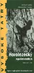
Horolezecký sprievodca obsahuje výber najkrajších klasických lezeckých výstupov na 17 tatranských štítov. Bol vydaný v roku 2002 a preistenie ciest sa odvtedy z veľkou pravdepodobnosťou zmenilo. Ale výber ciest má dodnes svoju hodnotu.
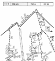
V úvode sú piktogramy, ktoré umožňujú orientovať sa v nákresoch. Mapky obsahujú aj prístupové trasy ku štítom. Vysvetlivky aj v angličtine, nemčine a francúzštine. 76 strán.
Sprievodcu pripravili známi slovenskí horolezci Róbert Gálfy a Alexander Luczy. "Horolezecký sprievodca – výber najkrajších klasických ciest (I. diel) je určený predovšetkým ľuďom, ktorí prídu do Tatier prvýkrát a chcú si niečo pekné vyliezť. Orientovali sme sa hlavne na južné a juhozápadné steny s pevnou skalou, ktoré v prípade pekného počasia poskytujú naozaj pôžitkové lezenie," píše jeden z autorov, Róbert Gálfy.
Nižšie uvádzame ukážky zo sprievodcu, počnúc jeho úvodom.
Z úvodu
Vysoké Tatry sú najvyšším pohorím Karpatského oblúka. Vrcholia Gerlachovským štítom vysokým 2564 metrov. Základnou horninou je žula. Steny sú väčšinou sklonené, výnimočne zvislé a previslé, ako napríklad Malý Ganek so svojou Galériou. V porovnaní s Vysokými Tatrami je granit skupiny Mont Blancu strmší a kompaktnejší. Vysoké Tatry boli kedysi zaľadnené, čoho svedkom sú vyhladené platne a mnohé jazerá. V súčasnosti ľadovce v Tatrách neexistujú. Začiatkom leta sa stretávame v dolinách, pod stenami a v žľaboch (napr. pri zostupoch) so snehom. V tomto prípade sú mačky a čakan nevyhnutné.
Opísané priestupy stien sú až 900 metrov vyské. Južné a západné steny majú najkrajšiu skalu, sú preto najnavštevovanejšie.
V minulých dvoch rokoch začala skupina tatranských lezcov s osadzovaním nitov v najpopulárnejších lezeckých cestách Tatier. Okrem ciest, ktoré takto zaistili, nájdete skoby a nity len sporadicky. Výstupy majú alpský charakter, schopnosti samostatne zaobchádzať s vklínencami (rocks), friends a skobami sú preto absolútnou podmienkou. Pri väčšine zostupov nie je nutné zlaňovať.
Obtiažnosť výstupov je ohodnotená stupnicou UIAA. Porovnanie s fancúzskou kvalifikáciou je priložené. Hrebene nám poskytujú väčšinou ľahké lezenie a I. a v II. stupni obtiažnosti.
Pred túrami sa dá prenocovať vo vysokohorských chatách. Všetky výstupy sa dajú však podniknúť priamo z tatranských osád za jeden deň. V tomto prípade však treba počítať s dlhými alpskými nástupmi a zostupmi.
Celé Tatry sú národným parkom s prísnou ochranou prírody. Voľné prenocovanie v dolinách, svojvoľné bivakovanie, kladenie ohňa, skracovanie chodníkov, prístup do niektorých prísne chránených dolín, zbieranie kvetov, atď. sú zakázané. Prosíme o dodržanie všetkých predpisov ohľadne ochrany prírody.
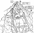
Ukážky zo sprievodcu
Východiskom na Voliu vežu zo slovenskej strany je Mengušovská dolina. Volia veža má v sprievodcovi zaznamenaných 5 výstupových trás.
Vysoké Tatry - Horolezecký sprievodca - vypredané Cena: 6.47 EUR Mierka: 0 Kategória: Horolezectvo Vydavateľ: AV studio, s.r.o. Vydanie 1. Rok vydania: 2002 ISBN: 80-88779-08-1 Počet strán: 76 Mäkká väzba Rozmery: 10.00 x 20.90 cm