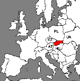
Susedné krajiny: Česká republika (CZ), Poľsko (PL), Ukrajina (UA), Maďarsko (HU), Rakúsko (AT)
Geografické vymedzenie
Najjužnejší bod 47 stupňov 43'55" severnej zemepisnej šírky (Patince)
Najsevernejší bod 49 stupňov 36'54" severnej zemepisnej šírky (Oravská Polhora)
Najzápadnejší bod 16 stupňov 50'04" východnej dĺžky (Záhorská Ves)
Najvýchodnejší bod 22 stupňov 34'20" východnej dĺžky (Nová Sedlica)
Vzdialenosť od najzápadnejšieho do najvýchodnejšieho bodu: 428 km (Záhorska Ves - Nová Sedlica)
Odhadovaná najväčšia vzdialenosť Juh - Sever: 192 km (Štúrovo - Skalité)
Najnižšia a najvyššia úroveň nad morom: 95m (Bodrog) 2655 (Gerlach)
Podstatnú časť Slovenska pokrývajú horstvá, ktoré sú súčasťou Západokarpatského oblúka. Pohoria vytvárajú niekoľko súbežných pásiem, rozdelených dolinami, ktoré brázdia rieky (Váh na Považí, Hron na Pohroní). Vonkajšie pásmo tvoria nižšie zalesnené horstvá: Malé Karpaty, Biele Karpaty, Javorníky, Nízke Beskydy. Vnútorná časť, to sú nižšie Strážovské vrchy, Veľká Fatra, Malá Fatra a vyššie položené Nízke a Vysoké Tatry s najvyšším vrcholom Karpatského oblúka, ktorým je Gerlachovský štít (2655 m). Na južnom Slovensku sa rozprestierajú tri nížiny: Záhorská (Borská) nížina a Podunajská nížina na západe a Východoslovenská nížina na východe. Juhozápadnú hranicu lemuje Dunaj.
CLIMATE
Continental with hot summers and cold winters.
The coldest month is January (0°C), warmest July and August (26°C). In high altitude the snow lasts for 130 days per year.