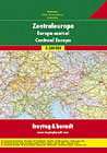
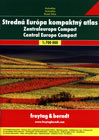
The great road atlas of Central Europe, harbound, and smaller edition - Central Europe Compact, paperback
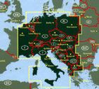
Central Europe - Road Atlas 1:500000
Road atlas includes these countries: Austria, Albania, Belgium, Bosnia and Herzegovina, Switzerland, the Czech Republic, Germany, France East, Hungary, Croatia, Italy, Luxembourg, Macedonia, Netherlands, Poland, Slovenia, Slovakia, former Yugoslavia: Serbia and Monte Negro, Romania (west strip), Bulgaria (west, icluding Sofia).
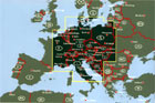
Central Europe Compact Road Atlas 1:700000
Road atlas includes these countries: the United Kingdom (south from London), France (east part), Netherlands, Denmark (south), Luxembourg, Belgium, Switzerland, Sweden (south), Germany, Italy (north, central part), Monaco, Poland, the Czech Republic, the Slovak Republic, Austria, Hungary, Slovenia, Croatia, Bosnia and Herzegovina, Serbia (west), Monte Negro, Albania (west), Romania (northwest), Ukraine (far west) Belarussia (west), Latvia (west), Kaliningrad and surroundings.
There are maps sheets in scale1:700000, tourist information, index with postal codes, distances in kilometers, car ferries in the road atlas.