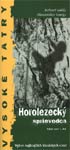
A small climbing guide contains selected classical routes with maps to 17 pinnacles in the High Tatras. It was published at 2002. because of this take this guidebook as an information about the most popular climbing routes in the High Tatras.
At the beginning of the guide are pictographs labeled in Slovak, English, German and French languages. Pictographs allow users to understand meaning of maps. 76 pages.
Both authors - Robert Galfy and Alexander Luczy - are well known Slovak mountaineers.
Below is their introduction to the guide.
Introduction
The High Tatras are the highest mountains in the Carpathians. The highest summit is Gerlachovsky stit with 2654 meters. The granite is generally slabby, with exception of Maly Ganek with its vertical and overhanging "Gallery". To compare, the rock with that of Mont Blanc range, the latter is generally steeper and more compact.
In the past the High Tatras were glaciated, the polished rocks and numerous lakes are evident of this. In early summer snow is still to be found at the foot of the cliffs and in descent gullies. Crampons and ice axe are therefore necessary.
The routes can be up to 900 m in length, the best rock being in the South and West. This is why the routes here are more popular. In the last two years, a group of local climbers have tried to set a route into the face with bolts. In any of the other most frequented routes, fixed bolts (or pitons) are only sporadically. Most descents do not require an abseil. Climbs are graded with the UIAA system; a comparison with French grades is given. Ridge traverses provide mountaineers with easy climbs of grade II and I. There are mountain huts for overnight accommodation. Alternatively climbs can be accessed from the valleys but expect a long walk-in!
The High Tatras is a National Park. This means that conservation is of a great importance. It is forbidden to camp or bivouac in the valleys, to light fires, use short cuts, pick flowers or even to hike in certain valleys. Please respect these restrictions.
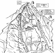
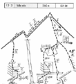
A sample from the mountaineering guidebook
The guide describes 5 routes at Volia veza pinnacle from Mengusovska dolina valley.
High Tatras - Climbing Guide - Sold out Price: EUR 6.47 Scale: 0 Category: Mountaineering, Climbing Published by: AV studio, s.r.o. Edition 1. Published in 2002. ISBN: 80-88779-08-1 76 pp. Paperback Dimensions: 10.00 x 20.90 cm