Contents
- Webcams
- Guide - Slovakia Document Store
- Trips around Bratislava
- Active Tourism
- Sightseeing Cruises on the Danube River
- Bratislava - Vienna by a Boat
- Photostories
- Climbing
- News
- News from Slovakia in English
- News from Slovakia in Slovak
- Neighbors of Slovakia
- What World Thinks
- Funny outdoor
- Recorder
- Bookstore
- Slovak Language for Foreigners
- Slovak Folk Music
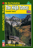
- Guidebooks to Hiking in Slovakia (English)
- Films - Documentaries and Travelogues
- New Year Cards
- Contacts